Fire lookout · Garfield County, Washington
Clearwater Lookout
Also known as Clearwater Lookout Cabin
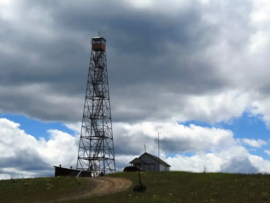
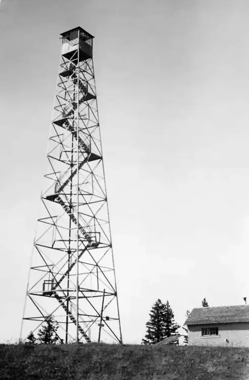
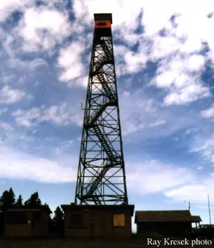
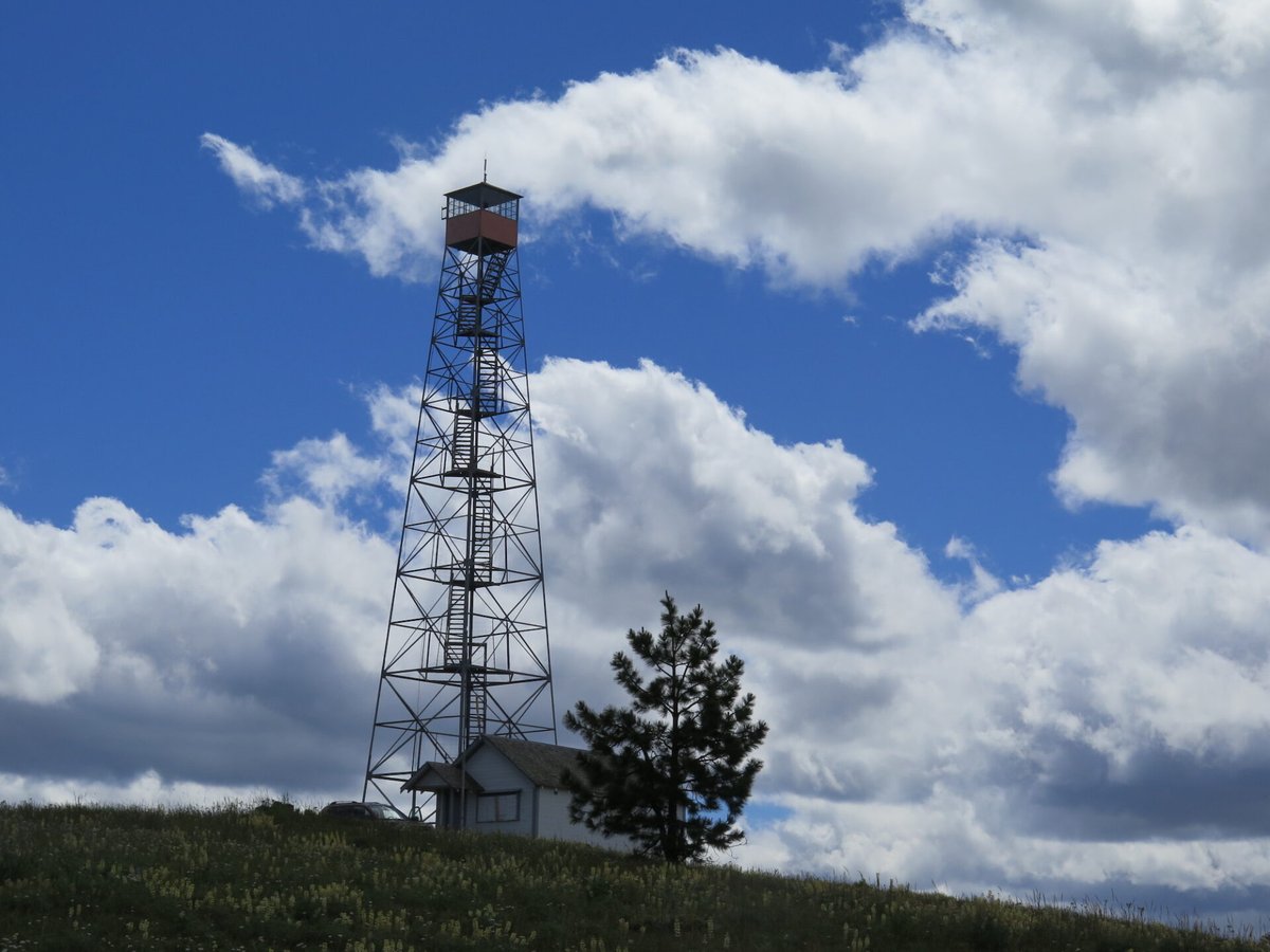
A 1933 CCC-built Aermotor steel tower above the old Clearwater Ranger Station, with a 1935 CCC cabin now rented year-round and the tower kept in reserve for emergencies.
- Standing
- Rentable
- Closed
- Verified
Closed
The site is closed to visitors. Tower itself closed to public access per the Recreation.gov listing; OpenStreetMap separately tags the node access=no (no climbing tag found). The rental cabin at its base is open to paying guests year-round, with car access June 1-Oct 31.
Visit & stay
You can rent this lookout for overnight stays through recreation.gov.
- Season
- year-round
- Getting there
- Access by car is from June 1 to October 31 weather permitting.
Overview Clearwater Lookout Cabin is a single story, wood frame structure constructed in 1935. It is tucked at the base of the Clearwater Lookout tower, a 94-foot steel tower constructed by the Civil Conservation Corps in 1933. Through the years, the tower has been used as a landmark by the public and employees of the Forest Service. The tower is no longer manned during fire season, but it is used on occasion during extreme fire conditions. The tower is closed to public access, but the rental cabin is open year-round. The cabin is located about 25 miles south of Pomeroy, Washington in the Umatilla National Forest. Access by car is from June 1 to October 31 weather permitting. In winter, access is limited to cross country skis, snowshoes or snowmobile. Recreation Horseback riding and hiking trails can be accessed from the cabin. During spring and summer, guests can enjoy a short and scenic drive along the Tucannon River to Sunset Point. Mushroom and berry picking may also entertain guests. At night, guests enjoy gazing up at the star-filled sky. Winter brings avid snowmobilers and skiers to explore its groomed trails. Facilities The cabin is divided into a kitchen and a bedroom, and is furnished with four extra-long single beds. It is kept warm in the winter by a propane heater, and features propane lights, a cook stove and a refrigerator, as well as some cookware, dishes and utensils. However it is suggested that visitors bring their own dishes, pots, pans and utensils. There is a firepit and picnic table outside. An outhouse is located nearby. The cabin was updated inside and out during the summer of 2023. There is no water on-site, so visitors must bring plenty for drinking, cooking and washing. Other things to bring include bedding or sleeping bags, flashlights, dish soap and other basic camping gear. General cleaning is expected before departure. Mop, bucket, broom, and cleaning supplies provided (water is not provided). Cleaning service is not always available between guests, please leave the cabin as you would like to find it. Natural Features Perched at 5,600 feet elevation, Clearwater Lookout Cabin offers panoramic views of the expansive Wenaha-Tucannon Wilderness, from sunrise to sunset. The rugged landscape of the wilderness stretches across the northern Blue Mountains of southeastern Washington and northeastern Oregon. The mountain slopes are carpeted with bunchgrass, lodgepole pine and subalpine fir. An array of wildlife, including Rocky Mountain Elk, bighorn sheep, white-tailed and mule deer, black bears, cougars and coyotes may be spotted. Nearby Attractions The nearest general stores and gas stations are in Pomeroy, a 40-minute drive from the cabin. Charges & Cancellations For Reservation Changes & Cancellation Fees, please see Rules & Reservation Policies.
Book on recreation.gov (opens recreation.gov)
Rental details from recreation.gov, checked 19 Oct 2026. Rules, fees and seasons change, so confirm on the booking page before you go. Data source: ridb.recreation.gov
Access
Closed. See the warning at the top of this page.
- Can you climb it?
- No
- Road to the top?
- No, you have to hike
- Trail
- Car access June 1 to October 31, weather permitting; snowshoe, ski or snowmobile the rest of the year (recreation.gov).
- Staffing
- Not staffed (as of 2026)
Facts
- Status
- Type
- Cab on a towerAermotor MC-39 steel towerThe design: Aermotor MC-39
- Built of
- Steel
- Built
- 1908 sources disagree
- Height
- 90 ft (27.4 m)
- Elevation
- 5,668 ft (1,728 m)
- Agency
- US Forest Service - Umatilla National Forest
- Land
- Federal land
- Location
- Garfield County, Washington
- Coordinates
- 46.20297, −117.57518
- Registers
- This entry
- VerifiedResearched, then checked independently. Updated 19 Oct 2026.
- Firefinder id
us-wa-clearwater-2
View from the cab
What you see from the cab: every ridge out to about 93 miles, the named peaks in sight, and other fire lookouts within view, worked out from terrain data in your browser.
Downloads about 3.7 MB of terrain data the first time.
Or see what it could see on the map: the ground in its line of sight.
History
Then and now
- 1908 BuiltClearwater Ranger Station established from a converted trapper's cabin (predates the current tower)Source: willhiteweb.com
- No record between 1908 and 1933
- 1933 BuiltSteel Aermotor MC-39 tower built by a ~200-man CCC camp working the Asotin District; conflicts with NHLR's own 'Built 1938' fieldSources: willhiteweb.com, nhlr.org
- 1935 BuiltGround cabin at the base of the tower built by the CCCSources: nhlr.org, firelookout.com
- 1938 Built'Built' field on NHLR detail pageSource: NHLR register entry
- No record between 1938 and 2021
- 2021 Last staffedTower pressed into service as a temporary radio repeater site during the Lick Creek (Dry Gulch) fire, August 2021; described as still available for emergencies rather than routinely staffedSource: nhlr.org
- 2022 Added to the National Historic Lookout RegisterDate registered per NHLR detail page: April 11, 2022Source: NHLR register entry
- 2023 RestoredRental cabin updated inside and outSource: recreation.gov
- TodayStandingIt still stands, as far as our sources know.
Old maps of this spot
USGS topographic maps from the years a lookout stood may show it, often as a small symbol labelled “Lookout”. See the old topo maps around it on the Firefinder map, or find every scanned sheet of this spot on USGS TopoView (opens another site) (click the spot there to list them, with dates and downloads).
Story
Researched 4 Oct 2026, fact-checked.
Clearwater Lookout
Before there was a tower, there was a trapper's cabin. Around 1908 the Forest Service converted an old trapper's cabin into the Clearwater Ranger Station, in the Blue Mountains south of Pomeroy, Washington; within a year the surrounding glade had been fenced off as a ranger station pasture, with corrals for sheep built nearby about a year after that.1 In 1928 Ranger Grover Blake put up a three-room house there from scrap and donated lumber, and moved a one-room cabin down from Teal Spring to serve as guards' quarters.1
The steel tower that still stands came five years later. A Civilian Conservation Corps camp of about 200 men worked the Asotin District for roughly four months in 1933, and among their projects was a new garage and steel tower at Clearwater.1 It was an Aermotor-brand MC-39 tower, one of a run of prefabricated steel towers the Aermotor Company of Chicago supplied to the Pacific Northwest starting in the 1920s and in greater numbers through the following decade, mostly east of the Cascades.2 Sources don't agree on its height: the Umatilla National Forest's own inventory calls it 90 feet, lookout historian Ray Kresek gives 94 feet, and firelookout.com gives 82.2,3 The ground cabin at the tower's base, where overnight guests stay today, followed two years later, in 1935, also CCC-built.2,3 Oddly, the lookout's own national register entry lists 1938 as the "Built" year even though its own description credits the 1933 CCC crew with the tower — likely a mix-up between the tower's construction and some other milestone; this story follows the CCC account.2
By 1939 Clearwater had become the headquarters for the district's Protective Assistant, a role it took over from Diamond Peak, and the Forest Service ran new telephone line to it with a double switchboard.1
The tower last did real work in August 2021, when its height made it useful as a temporary radio repeater during the Lick Creek (Dry Gulch) fire in southeast Washington.2 It isn't staffed during fire season anymore, but the Forest Service keeps it available for extreme fire conditions, and the tower itself is closed to public access.2,4 OpenStreetMap also tags the structure as access restricted.5 The cabin, though, is rented out year-round through Recreation.gov: a kitchen-and-bedroom cabin furnished with four extra-long single beds, propane heat, lights and a cook stove, no running water on site, reachable by car from June through October and by snowshoe, ski or snowmobile the rest of the year. It was refreshed inside and out in 2023.4
- Clearwater Lookout - Umatilla National Forest, willhiteweb.com, http://www.willhiteweb.com/washington_fire_lookouts/clearwater_lookout/umatilla_national_forest_048.htm (accessed 2026-10-04). ↩
- Clearwater Lookout, National Historic Lookout Register (nhlr.org), http://nhlr.org/lookouts/us/wa/clearwater-lookout/ (accessed 2026-10-04). ↩
- Clearwater Fire Lookout Tower, firelookout.com, https://www.firelookout.com/wa/clearwater.html (accessed 2026-10-04). ↩
- Clearwater Lookout Cabin, Umatilla National Forest, Recreation.gov, https://www.recreation.gov/camping/campgrounds/234271 (accessed 2026-10-04). ↩
- OpenStreetMap node 5907183991, OpenStreetMap, https://www.openstreetmap.org/node/5907183991 (accessed 2026-10-04). ↩
Photos
Photos keep their own rights and are shown with credit. Is one of these yours? You can ask for a different credit or for removal.
Where sources disagree
We show disagreements between sources instead of quietly picking one. If you know which is right, please tell us.
Sources disagree on the year it was built.
- NHLR: 1938
- firelookout.com -- Rex Kamstra's Forest Fire Lookout Page: 1938
- recreation.gov: 1935
- TrailChick: Washington State Fire Lookouts: 1933
Sources give different build years. Often one counts the first lookout on the site and another the structure there now.
Sources
- National Historic Lookout Register (NHLR) (opens another site) Gave us: name, location, county, elevation, what it is built of, register numbers, agency, dates, photos, links National Historic Lookout Register (nhlr.org) · All rights reserved (American Resources, Inc.); facts extracted only, no prose copied. · retrieved 4 Oct 2026
- Forest Fire Lookout Association (FFLA) - US lookout lists (opens another site) Gave us: type, status, register numbers, links Forest Fire Lookout Association (firelookout.org) · No licence stated; facts extracted only, no prose copied. · retrieved 8 Oct 2026
- Recreation Information Database (recreation.gov) (opens another site) Gave us: ownership, access, rental details, links Data source: ridb.recreation.gov · Public data from the US government · retrieved 19 Oct 2026
- Forest Fire Lookout Association: lookout rentals (opens another site) Gave us: rental details, links Forest Fire Lookout Association rentals list (firelookout.org) · No licence stated; facts extracted only (state, name, booking link, manager, closure note), no prose copied. The FFLA says it is not involved in managing any rental program. · retrieved 19 Oct 2026
- firelookout.com -- Rex Kamstra's Forest Fire Lookout Page (opens another site) Gave us: design, photos, links firelookout.com · No licence stated on the site; facts only (coordinates, elevation, built/destroyed years, design, agency). Photos mirrored with the site's stated credit. · retrieved 4 Oct 2026
- OpenStreetMap -- fire lookout structures (opens another site) Gave us: links © OpenStreetMap contributors · ODbL 1.0. (c) OpenStreetMap contributors. · retrieved 4 Oct 2026
- FOREST LOOKOUTS -- western US (Ron Kemnow's weebly sites) (opens another site) Gave us: height, links Ron Kemnow's Forest Lookouts sites (westlookouts, californialookouts, idaholookouts, montanalookouts, oregonlookouts and washingtonlookouts .weebly.com) · No licence stated; facts only (county, land manager, status word, coordinates where the page's own map widget gives them, township-range-section, height and design hints, links). The site's own newspaper quotes, citations and narrative are not reproduced. · retrieved 8 Oct 2026
- TrailChick: Washington State Fire Lookouts (opens another site) Gave us: photos TrailChick (trailchick.com) · No licence stated; facts only (county, land manager, coordinates, elevation, lookout type, years built). The guide's text is not reproduced; its card photos are listed with credit to TrailChick, for the project's photo mirroring. · retrieved 8 Oct 2026
- Firefinder research Gave us: summary, design, status, agency, access, staffing, visiting details, dates, links, fact-check Firefinder research (sources cited in the story footnotes) · Our own research notes; each fact cites its source in the lookout's story
More about this lookout elsewhere
- NHLR register entry US 1522 (nhlr.org) (opens another site)
- Recreation.gov listing (opens another site)
- Clearwater Lookout - Umatilla National Forest (willhiteweb.com) (opens another site)
- FFLA Washington lookout list (firelookout.org) (opens another site)
- FFLA lookout rentals list (firelookout.org) (opens another site)
- Clearwater Lookout - Trailchick.com (opens another site)
- Clearwater on firelookout.com (Rex Kamstra) (opens another site)
- Clearwater on Forest Lookouts, western US (Ron Kemnow) (opens another site)
- OpenStreetMap node 5907183991 (opens another site)
Firefinder takes facts (places, dates, numbers) from these sources and writes its own words. See all sources and licences.