Fire lookout · Whatcom County, Washington
Crater Mountain Lookout Site
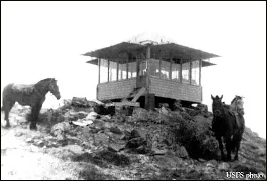
Whatcom County, WA: camp from 1929, L-4 cab on the summit in 1932; abandoned 1968, cabin burned 1973; remnants of a phone pole and tramway; public status unstated.
- Gone
- Access unknown
- Verified
Gone: The lookout no longer stands. Only the site is left. The cabin burned in 1973; photo captions describe a phone pole and tramway remnants
Visit & stay
Gone: site only. The lookout no longer stands, so there is nothing to climb or rent.
Access
Access unknown
We do not know the access rules. Check with the land manager before you go.
- Road to the top?
- No, you have to hike
- Trail
- About 7 miles one way with about 6,400 feet of gain, per WillhiteWeb; the route is mostly easy but exposed class 3 scrambling, with perhaps one low class 4 move
Facts
- Status
- Type
- Ground-level cabL-4 cabs: the first on the primary summit in 1932, a second on a minor summit a mile eastThe design: L-4
- Built of
- WoodGoing by its design; no source says so in words.
- Built
- 1932
- Height
- Unknown
- Elevation
- 7,761 ft (2,366 m)
- Agency
- U.S. Forest Service
- Land
- Federal land
- Location
- Whatcom County, Washington
- Coordinates
- 48.73925, −120.92010
- Registers
- This entry
- VerifiedResearched, then checked independently. Updated 9 Oct 2026.
- Firefinder id
us-wa-crater-mountain
View from the cab
What the lookout saw from its cab: every ridge out to about 93 miles, the named peaks in sight, and other fire lookouts within view, worked out from terrain data in your browser.
This lookout is gone. The view is reconstructed from its recorded site and a typical height for a lookout like it.
Downloads about 4.1 MB of terrain data the first time.
Or see what it could see on the map: the ground in its line of sight.
History
Then and now
- 1929 First staffedCamp established; George Hadley named as the first watcherSources: firelookout.com, willhiteweb.com
- 1932 BuiltL-4 cab built on the primary summitSources: firetower.org, firelookout.com
- No record between 1932 and 1951
- 1951 StaffedEarle and Bonnie St. AubinSources: firelookout.com, willhiteweb.com
- 1952 StaffedGary Snyder; HistoryLink says he spent six weeks on the mountainSources: historylink.org, firelookout.com, willhiteweb.com
- 1955 Replaced by a new structureTommy Buller nailed the old cab shut and moved the firefinder to a newer L-4 cab on a lower summit a mile east; FFLOS dates the new cab to about 1950Sources: firetower.org, firelookout.com, willhiteweb.com
- 1968 AbandonedSite abandoned entirelySources: firetower.org, firelookout.com
- 1973 BurnedThe cabin burnedSources: firetower.org, firelookout.com
- No record between 1973 and 2012
- 2012 Added to the Former Fire Lookout Sites RegisterRegistered March 25, 2012 (FFLOS US 1234)Source: firetower.org
- TodayGoneThe lookout no longer stands. Only the site is left.
Old maps of this spot
USGS topographic maps from the years a lookout stood may show it, often as a small symbol labelled “Lookout”. See the old topo maps around it on the Firefinder map, or find every scanned sheet of this spot on USGS TopoView (opens another site) (click the spot there to list them, with dates and downloads).
Story
Researched 9 Oct 2026, fact-checked.
Crater Mountain sits in Whatcom County, on the Mt. Baker-Snoqualmie National Forest.1 HistoryLink places it about 30 miles east-northeast of Marblemount, in the North Cascades.2
The summit began as a camp in 1929, and George Hadley is named as its first watcher.3,4 An L-4 cab went up on the primary summit in 1932.1,3 Before the cab, a watcher who spotted smoke sighted it on the firefinder, then walked 7.5 miles down to a cabin with a phone line to Marblemount.4 Late in summer, getting water meant descending the steep north side to Jerry Glacier for chunks of ice, which were hauled back up to melt.4 Supplies came up by cable, and the last stretch was on foot.4
Records list Earle and Bonnie St. Aubin in 1951 and Gary Snyder in 1952.3,4 HistoryLink says Snyder spent six weeks on the mountain that year.2 In 1955 Tommy Buller nailed the old cab shut and moved the firefinder to a newer L-4 cab on a lower summit a mile east.3,4
The register gives 1968 as the year the site was abandoned and 1973 as the year the cabin burned.1,3 It dates the newer east cab to about 1950, while the other two pages say 1955.1,3,4
The register lists the site at 7,761 feet, while two other pages give 8,128 feet.1,3,4
WillhiteWeb's photo captions document what is left: one phone pole still standing near treeline, and tramway remnants near the cliff section.4 The register places the site on Forest Service land, but none of the sources read says whether the summit is open to visitors.1 WillhiteWeb describes the climb as seven miles one way, with about 6,400 feet of gain and mostly easy but exposed class 3 scrambling, with perhaps one low class 4 move.4
- Crater Mountain Lookout Site, Former Fire Lookout Sites, http://firetower.org/lookouts/us/wa/crater-mountain-lookout-site/ (accessed 2026-10-09). ↩
- Fire Lookouts in Washington, HistoryLink.org, https://www.historylink.org/File/23254 (accessed 2026-10-09). ↩
- Crater Mtn. Fire Lookout Cabin, firelookout.com, https://www.firelookout.com/wa/cratermtn.html (accessed 2026-10-09). ↩
- Crater Mountain Lookout Site, WillhiteWeb.com, http://willhiteweb.com/fire_lookouts/crater_mountain_lookout/jerry_glacier_053.htm (accessed 2026-10-09). ↩
Photos
Photos keep their own rights and are shown with credit. Is one of these yours? You can ask for a different credit or for removal.
Sources
- Former Fire Lookout Sites Register (FFLOS) (opens another site) Gave us: name, location, county, elevation, what it is built of, register numbers, agency, ownership, dates, photos, links Former Fire Lookout Sites Register (firetower.org) · All rights reserved (American Resources, Inc.); facts extracted only, no prose copied. · retrieved 4 Oct 2026
- Forest Fire Lookout Association (FFLA) - US lookout lists (opens another site) Gave us: type, status, register numbers, links Forest Fire Lookout Association (firelookout.org) · No licence stated; facts extracted only, no prose copied. · retrieved 8 Oct 2026
- firelookout.com -- Rex Kamstra's Forest Fire Lookout Page (opens another site) Gave us: links firelookout.com · No licence stated on the site; facts only (coordinates, elevation, built/destroyed years, design, agency). Photos mirrored with the site's stated credit. · retrieved 4 Oct 2026
- FOREST LOOKOUTS -- western US (Ron Kemnow's weebly sites) (opens another site) Gave us: links Ron Kemnow's Forest Lookouts sites (westlookouts, californialookouts, idaholookouts, montanalookouts, oregonlookouts and washingtonlookouts .weebly.com) · No licence stated; facts only (county, land manager, status word, coordinates where the page's own map widget gives them, township-range-section, height and design hints, links). The site's own newspaper quotes, citations and narrative are not reproduced. · retrieved 8 Oct 2026
- WillhiteWeb.com: Washington Fire Lookouts (opens another site) Gave us: links WillhiteWeb.com · No licence stated; names and page links only (the site's photos and text are not reproduced). · retrieved 8 Oct 2026
- Firefinder research Gave us: summary, design, status, agency, staffing, visiting details, dates, links, fact-check Firefinder research (sources cited in the story footnotes) · Our own research notes; each fact cites its source in the lookout's story
More about this lookout elsewhere
- FFLOS register entry US 1234 (firetower.org) (opens another site)
- Fire Lookouts in Washington (HistoryLink.org) (opens another site)
- FFLA Washington lookout list (firelookout.org) (opens another site)
- Crater Mtn. on firelookout.com (Rex Kamstra) (opens another site)
- Crater Mountain on Forest Lookouts, western US (Ron Kemnow) (opens another site)
- Crater Mountain on WillhiteWeb.com Washington Fire Lookouts (opens another site)
Firefinder takes facts (places, dates, numbers) from these sources and writes its own words. See all sources and licences.