Fire lookout · Kittitas County, Washington
Goat Peak Lookout Site
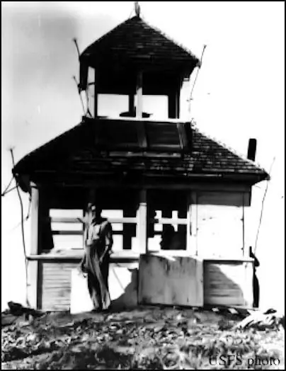
Kittitas County, WA Goat Peak lookout: D-6 cabin 1928, R-6 tower about 1960; cab sold and moved to the Teanaway Valley in 1969, visible from the road.
- Moved
- Open to the public
- Verified
The lookout that stood here was moved. Now at Teanaway Valley
Moved: The structure was moved. The map shows where it stands now; the timeline says where it came from. Cab sold and moved to the Teanaway Valley in 1969. A 2017 hike report calls the summit a former lookout site with trees around the old site.
Visit & stay
Not rentable. As far as we know, this lookout cannot be booked for overnight stays.
Access
Open to the public. Summit reached on Forest Service land by an unsigned trailhead, per a July 2017 hike report. No current access rules found. The moved cab went to a private buyer in 1969 and is not part of this access.
- Can you climb it?
- Unknown
- Road to the top?
- Unknown
- Trail
- Reached from Easton by Cabin Creek Road and FS Road 41; the trailhead is unsigned, with parking for 3 or 4 cars (2017 hike report)
- Staffing
- Unknown
Facts
- Status
- Type
- Cab on a towerR-6 flat cabin on a 10-foot treated timber tower (about 1960), replacing a D-6 cupola cabin built in 1928The designs: R-6, D-6
- Built of
- Not recorded
- Built
- 1928
- Height
- Unknown
- Elevation
- 5,100 ft (1,555 m)
- Agency
- U.S. Forest Service
- Land
- Federal land
- Location
- Kittitas County, Washington
- Coordinates
- 47.19351, −121.19917 sources disagree
- Registers
- This entry
- VerifiedResearched, then checked independently. Updated 9 Oct 2026.
- Firefinder id
us-wa-goat-peak-2
View from the cab
What you see from the cab: every ridge out to about 93 miles, the named peaks in sight, and other fire lookouts within view, worked out from terrain data in your browser.
The structure was moved. This view is from the position Firefinder shows for this record, at a typical height for a lookout like it.
Downloads about 4.3 MB of terrain data the first time.
Or see what it could see on the map: the ground in its line of sight.
History
Then and now
- 1927 Event$800 allotted for a lookout house on Goat Peak (Weebly, quoting the Leavenworth Echo)Source: washingtonlookouts.weebly.com
- 1928 BuiltD-6 cupola cabin builtSources: firetower.org, firelookout.com, wta.org
- 1933 StaffedAdam Ehl listed as a known lookoutSource: firelookout.com
- No record between 1933 and 1960
- 1960 Replaced by a new structure10-foot treated timber tower with R-6 flat cabin replaced the D-6. Register says about 1960; Firelookout says 1960; the 2017 hike report says 1956.Sources: firetower.org, firelookout.com, wta.org
- 1969 MovedCab and tower sold to a local resident (register) or local family (hike report), who moved them to the Teanaway ValleySources: firetower.org, firelookout.com, washingtonlookouts.weebly.com
- No record between 1969 and 2012
- 2012 Added to the Former Fire Lookout Sites RegisterDate registered per FFLOS detail page: July 20, 2012Source: FFLOS register entry
- Date unknown MovedThe lookout was moved to Teanaway Valley.Source: FFLA
- TodayMovedThe structure was moved. The map shows where it stands now; the timeline says where it came from. When it came down is not recorded.
Old maps of this spot
USGS topographic maps from the years a lookout stood may show it, often as a small symbol labelled “Lookout”. See the old topo maps around it on the Firefinder map, or find every scanned sheet of this spot on USGS TopoView (opens another site) (click the spot there to list them, with dates and downloads).
Story
Researched 9 Oct 2026, fact-checked.
The Goat Peak lookout covered here stood in Kittitas County, in the Wenatchee National Forest, about 12 miles west of Cle Elum.1,2
In 1927, $800 was set aside for a lookout house on Goat Peak.3 The register and a 2017 hike report both date the first cabin, a D-6 cupola cabin, to 1928.1,4
An item quoted on the Weebly page, printed in January 1928, describes an August 5 flight over the forest. The note dropped from the plane said no fires had been seen yet. About half an hour later the lookout reported a fire on Cabin Mountain, and both fires were no more than three miles from the lookout.3
The Firelookout page lists Adam Ehl as a known lookout in 1933.2
About 1960, a 10-foot treated timber tower with an R-6 flat cabin replaced the D-6 cabin, according to the register.1 The Firelookout page gives the year as 1960.2 The 2017 hike report says an L-4 cabin replaced the D-6 in the late 1930s, and that the R-6 went up in 1956.4
In 1969 the cabin and tower were sold to a local resident and moved to the Teanaway Valley.1,3 The hike report says the buyers took it apart first.4
The moved lookout is still in the Teanaway Valley, according to that report. It can be seen from the Teanaway Road, on a hill behind the Teanaway general store.4 We found nothing that says who owns it today, so treat it as private property and do not go onto the land without permission.
The 2017 hike report describes FS Road 41 as a rough gravel road, and an unsigned trailhead with parking for three or four cars.4 The same report says trees surround the old lookout site, so the hikers went a short way down to a viewpoint for lunch.4 We did not find current access rules for the summit, and the 2017 report is the newest source we read.
- Goat Peak Lookout Site, Former Fire Lookout Sites, http://firetower.org/lookouts/us/wa/goat-peak-lookout-site/ (accessed 2026-10-09). ↩
- Goat Peak Fire Lookout Cabin, Firelookout, https://www.firelookout.com/wa/goatpeak163.html (accessed 2026-10-09). ↩
- Goat Peak, Forest Lookouts, https://washingtonlookouts.weebly.com/goat-peak.html (accessed 2026-10-09). ↩
- Goat Peak trip report, Washington Trails Association, July 19, 2017, https://www.wta.org/go-hiking/trip-reports/trip_report.2017-07-19.7071429147 (accessed 2026-10-09). ↩
Photos
Photos keep their own rights and are shown with credit. Is one of these yours? You can ask for a different credit or for removal.
Where sources disagree
We show disagreements between sources instead of quietly picking one. If you know which is right, please tell us.
Sources disagree on the location by 510 m.
- FFLA: 47.19351, −121.19917
- FFLOS: 47.19340, −121.19245
They share a register number.
The map uses the position from FFLA.
Sources
- Former Fire Lookout Sites Register (FFLOS) (opens another site) Gave us: name, county, elevation, register numbers, agency, ownership, dates, photos, links Former Fire Lookout Sites Register (firetower.org) · All rights reserved (American Resources, Inc.); facts extracted only, no prose copied. · retrieved 4 Oct 2026
- Forest Fire Lookout Association (FFLA) - US lookout lists (opens another site) Gave us: location, type, status, register numbers, links Forest Fire Lookout Association (firelookout.org) · No licence stated; facts extracted only, no prose copied. · retrieved 8 Oct 2026
- firelookout.com -- Rex Kamstra's Forest Fire Lookout Page (opens another site) Gave us: links firelookout.com · No licence stated on the site; facts only (coordinates, elevation, built/destroyed years, design, agency). Photos mirrored with the site's stated credit. · retrieved 4 Oct 2026
- FOREST LOOKOUTS -- western US (Ron Kemnow's weebly sites) (opens another site) Gave us: links Ron Kemnow's Forest Lookouts sites (westlookouts, californialookouts, idaholookouts, montanalookouts, oregonlookouts and washingtonlookouts .weebly.com) · No licence stated; facts only (county, land manager, status word, coordinates where the page's own map widget gives them, township-range-section, height and design hints, links). The site's own newspaper quotes, citations and narrative are not reproduced. · retrieved 8 Oct 2026
- Firefinder research Gave us: summary, design, status, agency, access, visiting details, dates, links, fact-check Firefinder research (sources cited in the story footnotes) · Our own research notes; each fact cites its source in the lookout's story
More about this lookout elsewhere
- FFLOS register entry US 1365 (firetower.org) (opens another site)
- Goat Peak trip report (Wednesday, Jul. 19, 2017) (Washington Trails Association) (opens another site)
- FFLA Washington lookout list (firelookout.org) (opens another site)
- Goat Peak on firelookout.com (Rex Kamstra) (opens another site)
- Goat Peak on Forest Lookouts, western US (Ron Kemnow) (opens another site)
Firefinder takes facts (places, dates, numbers) from these sources and writes its own words. See all sources and licences.