Fire lookout · Lewis County, Washington
National Lookout Site
State fire tower near Ashford, built 1936 with CCC labor; 1965 40-ft R-6 replacement removed or destroyed in 1969; footings and debris remain on a gated state-land road.
- Gone
- Open to the public
- Verified
Gone: The lookout no longer stands. Only the site is left. Lookout gone; the 1965 replacement tower was removed or destroyed in 1969. Sources describe footings and debris; the original cab's whereabouts are unknown
Visit & stay
Gone: site only. The lookout no longer stands, so there is nothing to climb or rent. You may still be able to visit the site.
Access
Open to the public. Hike is on state land; the road is probably gated at the start of its 4 miles, and visitors are asked not to block gates. No closure described
- Road to the top?
- No, you have to hike
- Trail
- About 4 miles of road walk if gated, with 1,100 feet of gain; route from Highway 706 east of Elbe, past the Nisqually River
Facts
- Status
- Type
- Cab on a tower1936: 60-ft wooden tower with 8x8 cab (CCC). 1965: 40-ft wooden DNR tower with R-6 live-in cabThe design: R-6
- Built of
- Not recorded
- Built
- 1936
- Height
- 40 ft (12.2 m)
- Elevation
- 3,604 ft (1,099 m)
- Agency
- Washington Division of Forestry/DNR
- Land
- Unknown
- Location
- Lewis County, Washington
- Coordinates
- 46.72430, −122.08338
- Registers
- This entry
- VerifiedResearched, then checked independently. Updated 9 Oct 2026.
- Firefinder id
us-wa-national
View from the cab
What the lookout saw from its cab: every ridge out to about 93 miles, the named peaks in sight, and other fire lookouts within view, worked out from terrain data in your browser.
This lookout is gone. The view is reconstructed from its recorded site and its recorded height.
Downloads about 4.1 MB of terrain data the first time.
Or see what it could see on the map: the ground in its line of sight.
History
Then and now
- 1936 Built60-ft wooden tower with 8x8 cab, built by the CCCSources: firetower.org, firelookout.com, washingtonlookouts.weebly.com
- 1942 StaffedDave Anderson was the lookout man in 1942Source: willhiteweb.com
- 1942 First staffedAircraft Warning Service post activated August 14, 1942 (Seattle Filter Center); manned 24 hours a day during WWIISources: washingtonlookouts.weebly.com, willhiteweb.com
- 1943 ClosedAWS post deactivated July 1, 1943Source: washingtonlookouts.weebly.com
- No record between 1943 and 1965
- 1965 MovedOld 1936 cab exhibited at the Southwest Washington Fair in 1965; a 1965 newspaper said it would go on display at Camp Six. Willhite could not find it todaySources: washingtonlookouts.weebly.com, willhiteweb.com
- 1965 Replaced by a new structure40-ft wooden DNR tower with R-6 live-in cab replaced the 60-ft tower. Forest Lookouts also gives 1964-66 from a state biennial reportSources: firetower.org, washingtonlookouts.weebly.com, willhiteweb.com
- 1969 Destroyed1965 tower removed (register) or destroyed (firelookout.com, Willhite) in 1969Sources: firetower.org, firelookout.com, willhiteweb.com
- No record between 1969 and 2012
- 2012 Added to the Former Fire Lookout Sites RegisterDate registered per FFLOS detail page: June 18, 2012Source: FFLOS register entry
- TodayGoneThe lookout no longer stands. Only the site is left.
Old maps of this spot
USGS topographic maps from the years a lookout stood may show it, often as a small symbol labelled “Lookout”. See the old topo maps around it on the Firefinder map, or find every scanned sheet of this spot on USGS TopoView (opens another site) (click the spot there to list them, with dates and downloads).
Story
Researched 9 Oct 2026, fact-checked.
The National Lookout stood in north central Lewis County, at 3,604 feet.1,2 It sat about 18 miles west-southwest of Mount Rainier.3 The register lists the Washington Division of Forestry/DNR as its administrator.1
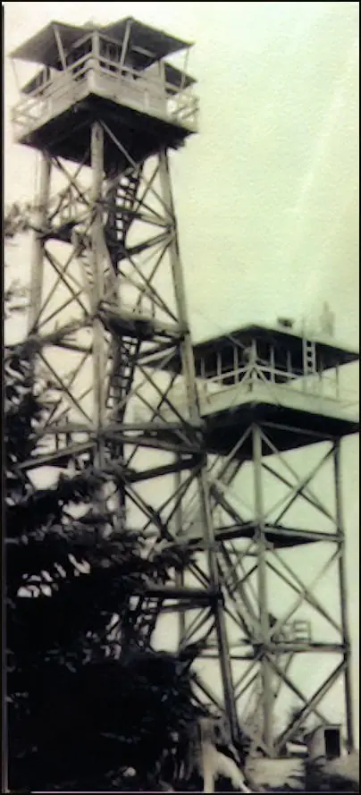
The first tower was a 60-foot wooden structure with an 8-by-8-foot cab, built in 1936 by Civilian Conservation Corps crews.1,3,2,4
During World War II the site was an aircraft warning post.4 It was activated on August 14, 1942, and deactivated on July 1, 1943.2,4 Willhite says it was manned around the clock during the war.4 Dave Anderson staffed the lookout in 1942.4 A 12-by-20-foot garage, paid for with Aircraft Warning Service funds, was kept for fire control after the war.4
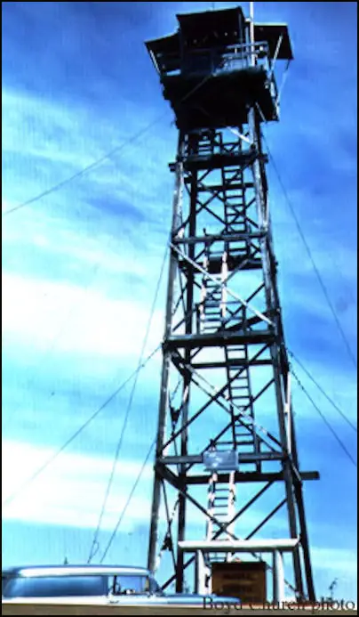
In 1965 a 40-foot wooden tower with a live-in R-6 cab replaced the 1936 lookout.1,2,4 A state report gives 1964 to 1966 for the replacement, so the sources differ slightly on the year.2 The old cab was exhibited at the Southwest Washington Fair in 1965.4 A newspaper of that year, quoted on the Forest Lookouts page, said it would go on display at Camp Six, a logging museum in Tacoma.2 Willhite could not say where the cab is today.4
The register says the 1965 tower was removed in 1969.1 Firelookout.com and Willhite say it was destroyed that year.3,4
Willhite sums it up bluntly: the town, the lookout and the view have all disappeared.4 Photos taken in 2016 and shared on the same page show footings beside the road, the remains of an outhouse, and bricks.4
Willhite describes a route from Highway 706 east of Elbe. He expects the last road to be gated at its start, and from that gate the walk to the summit is about 4 miles.4 The hike is on state land, where visitors should not block gates.4
- National Lookout Site, Former Fire Lookout Sites, http://firetower.org/lookouts/us/wa/national-lookout-site/ (accessed 2026-10-09). ↩
- National, Forest Lookouts, https://washingtonlookouts.weebly.com/national.html (accessed 2026-10-09). ↩
- National Fire Lookout Tower, firelookout.com, https://www.firelookout.com/wa/national.html (accessed 2026-10-09). ↩
- National Lookout, Tahoma State Forest, WillhiteWeb.com, http://www.willhiteweb.com/puget_sound_hiking/national_lookout/tahoma_state_forest_305.htm (accessed 2026-10-09). ↩
Photos
Photos keep their own rights and are shown with credit. Is one of these yours? You can ask for a different credit or for removal.
Sources
- Former Fire Lookout Sites Register (FFLOS) (opens another site) Gave us: name, location, county, elevation, register numbers, agency, dates, photos, links Former Fire Lookout Sites Register (firetower.org) · All rights reserved (American Resources, Inc.); facts extracted only, no prose copied. · retrieved 4 Oct 2026
- Forest Fire Lookout Association (FFLA) - US lookout lists (opens another site) Gave us: type, status, register numbers, links Forest Fire Lookout Association (firelookout.org) · No licence stated; facts extracted only, no prose copied. · retrieved 8 Oct 2026
- firelookout.com -- Rex Kamstra's Forest Fire Lookout Page (opens another site) Gave us: links firelookout.com · No licence stated on the site; facts only (coordinates, elevation, built/destroyed years, design, agency). Photos mirrored with the site's stated credit. · retrieved 4 Oct 2026
- FOREST LOOKOUTS -- western US (Ron Kemnow's weebly sites) (opens another site) Gave us: design, height, links Ron Kemnow's Forest Lookouts sites (westlookouts, californialookouts, idaholookouts, montanalookouts, oregonlookouts and washingtonlookouts .weebly.com) · No licence stated; facts only (county, land manager, status word, coordinates where the page's own map widget gives them, township-range-section, height and design hints, links). The site's own newspaper quotes, citations and narrative are not reproduced. · retrieved 8 Oct 2026
- WillhiteWeb.com: Washington Fire Lookouts (opens another site) Gave us: links WillhiteWeb.com · No licence stated; names and page links only (the site's photos and text are not reproduced). · retrieved 8 Oct 2026
- Firefinder research Gave us: summary, design, height, status, agency, access, visiting details, dates, links, fact-check Firefinder research (sources cited in the story footnotes) · Our own research notes; each fact cites its source in the lookout's story
More about this lookout elsewhere
- FFLOS register entry US 1287 (firetower.org) (opens another site)
- FFLA Washington lookout list (firelookout.org) (opens another site)
- National on firelookout.com (Rex Kamstra) (opens another site)
- National on Forest Lookouts, western US (Ron Kemnow) (opens another site)
- National Lookout on WillhiteWeb.com Washington Fire Lookouts (opens another site)
Firefinder takes facts (places, dates, numbers) from these sources and writes its own words. See all sources and licences.