Fire lookout · Skamania County, Washington
Smith Creek Butte Lookout Site
Skamania County, WA lookout built in the 1930s, rebuilt in 1946 and removed or destroyed in 1968; the site lies at the edge of the Mount St. Helens blast zone.
- Gone
- Restricted access
- Verified
Gone: The lookout no longer stands. Only the site is left. Second tower removed (register) or destroyed (Firelookout.com, Willhite) in 1968; Willhite reports a phone insulator, nails and an eyebolt at the site
Visit & stay
Gone: site only. The lookout no longer stands, so there is nothing to climb or rent.
Access
Restricted access
Access is seasonal, gated or needs a permit. Check before you go. Willhite describes a gated road on the north approach and a ford of the Muddy River on the south route; no source says whether the public may enter
- Road to the top?
- Unknown
- Trail
- No tower stands. North route: about 8 miles by bike on a gated road, then a short bushwhack. South route: from the Smith Creek Butte Trailhead, a ford of the Muddy River, then a trail Willhite says should exist
Facts
- Status
- Type
- Cab on a tower12-foot wooden L-4 tower (1930s), replaced in 1946 by a 20-foot treated timber tower with an L-4 cabThe design: L-4
- Built of
- Wood
- Built
- Unknown
- Height
- Unknown
- Elevation
- 3,820 ft (1,164 m)
- Agency
- U.S. Forest Service; Columbia National Forest in 1947, now listed under Gifford Pinchot National Forest by Washington Lookouts
- Land
- Federal land
- Location
- Skamania County, Washington
- Coordinates
- 46.20860, −122.05505
- Registers
- This entry
- VerifiedResearched, then checked independently. Updated 9 Oct 2026.
- Firefinder id
us-wa-smith-creek-butte
View from the cab
What the lookout saw from its cab: every ridge out to about 93 miles, the named peaks in sight, and other fire lookouts within view, worked out from terrain data in your browser.
This lookout is gone. The view is reconstructed from its recorded site and a typical height for a lookout like it.
Downloads about 4.1 MB of terrain data the first time.
Or see what it could see on the map: the ground in its line of sight.
History
Then and now
- 1932 EventShows as a lookout station on the 1932 USFS map; start date unknown (Willhite)Source: willhiteweb.com
- 1946 RebuiltFirst lookout dismantled and rebuilt about 30 feet north as a 20-foot treated timber tower with an L-4 cabSources: firetower.org, willhiteweb.com
- 1947 EventAbout 4,000 pounds of building materials flown in by airplane, per a Forest Log article quoted by Willhite and Washington LookoutsSources: willhiteweb.com, washingtonlookouts.weebly.com
- No record between 1947 and 1968
- 1968 RemovedSecond tower and cab removed (register) or destroyed (Firelookout.com, Willhite)Sources: firetower.org, firelookout.com, willhiteweb.com
- 1980 EventUSGS Geodimeter station set up at the site just before the eruption; photo dated April 25, 1980Source: willhiteweb.com
- No record between 1980 and 2012
- 2012 Added to the Former Fire Lookout Sites RegisterRegistered July 17, 2012 as US 1344, WA 244Source: firetower.org
- TodayGoneThe lookout no longer stands. Only the site is left.
Old maps of this spot
USGS topographic maps from the years a lookout stood may show it, often as a small symbol labelled “Lookout”. See the old topo maps around it on the Firefinder map, or find every scanned sheet of this spot on USGS TopoView (opens another site) (click the spot there to list them, with dates and downloads).
Story
Researched 9 Oct 2026, fact-checked.
Smith Creek Butte sits in Skamania County, Washington, about six miles east of Mount St. Helens.1 The lookout is gone.2,3,4
The first tower dates to the 1930s.2,3 The Former Fire Lookout Sites register describes it as a 12-foot wooden L-4 tower.2 Willhite's history is less certain. He says the butte already showed as a lookout station on a 1932 Forest Service map, but he does not know when it started.1
In 1946 the first lookout was taken down and rebuilt roughly 30 feet north of its former site, as a 20-foot treated timber tower with an L-4 cab.2,1 A 1947 Forest Log article, quoted by Willhite and by Washington Lookouts, reports that the Columbia National Forest's supervisor called a recent experiment in moving building materials by air a success.1,4 About 4,000 pounds of lumber and other supplies were flown in, a job that would otherwise have needed 25 pack horse loads.1,4
The second tower and cab came down in 1968.2,3,1 The register says it was removed, Firelookout.com says it was destroyed, and Willhite says it was "removed or destroyed." The sources agree on the year but not on the word.2,3,1
Willhite places the summit on the margin of the blast zone and writes that it came through the blast that flattened the forest.1 A photo caption on his page says the USGS set up a Geodimeter station at the lookout site shortly before the eruption. The photo was taken April 25, 1980.1
Willhite's visit photos include a phone insulator along the old trail, nails in a tree used for a phone line, and an eyebolt.1 His page notes a visit in 2023 and describes two routes in. From the north, a gated road runs about 8 miles by bike, followed by a short bushwhack. From the south, the route starts at a trailhead and requires a ford of the Muddy River.1 Washington Lookouts files the site under Gifford Pinchot National Forest.4 No source we read says whether the public may enter the site.
- Smith Creek Butte Lookout Site, WillhiteWeb.com, http://willhiteweb.com/fire_lookouts/smith_creek_butte/lookout_site_033.htm (accessed 2026-10-09). ↩
- Smith Creek Butte Lookout Site, Former Fire Lookout Sites, http://firetower.org/lookouts/us/wa/smith-creek-butte-lookout-site/ (accessed 2026-10-09). ↩
- Smith Creek Butte Fire Lookout Tower, Firelookout.com, https://www.firelookout.com/wa/smithcreekbutte.html (accessed 2026-10-09). ↩
- Smith Creek Butte, Forest Lookouts, Washington Lookouts, https://washingtonlookouts.weebly.com/smith-creek-butte.html (accessed 2026-10-09). ↩
Photos
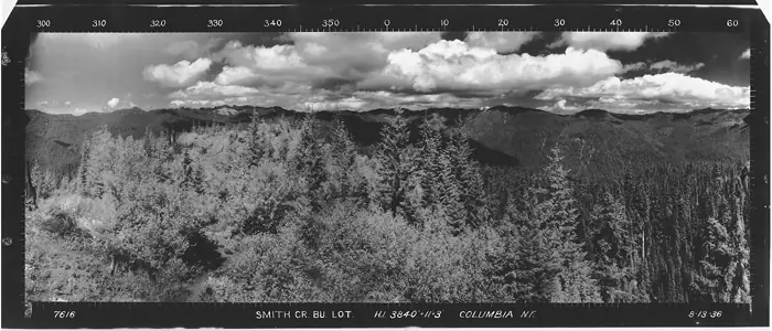
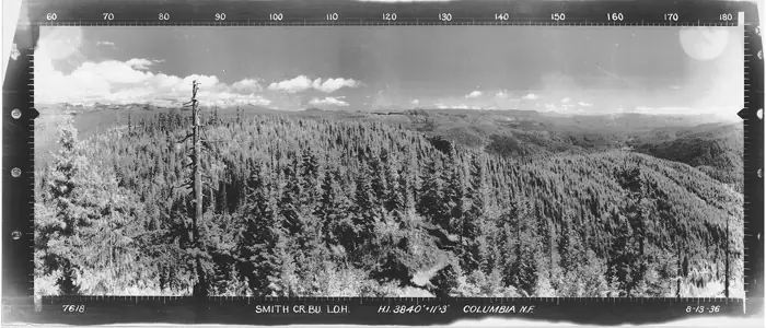
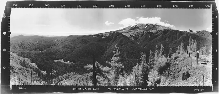
Photos keep their own rights and are shown with credit. Is one of these yours? You can ask for a different credit or for removal.
Sources
- Former Fire Lookout Sites Register (FFLOS) (opens another site) Gave us: name, location, county, elevation, what it is built of, register numbers, agency, ownership, dates, photos, links Former Fire Lookout Sites Register (firetower.org) · All rights reserved (American Resources, Inc.); facts extracted only, no prose copied. · retrieved 4 Oct 2026
- Forest Fire Lookout Association (FFLA) - US lookout lists (opens another site) Gave us: type, status, register numbers, links Forest Fire Lookout Association (firelookout.org) · No licence stated; facts extracted only, no prose copied. · retrieved 8 Oct 2026
- firelookout.com -- Rex Kamstra's Forest Fire Lookout Page (opens another site) Gave us: links firelookout.com · No licence stated on the site; facts only (coordinates, elevation, built/destroyed years, design, agency). Photos mirrored with the site's stated credit. · retrieved 4 Oct 2026
- FOREST LOOKOUTS -- western US (Ron Kemnow's weebly sites) (opens another site) Gave us: links Ron Kemnow's Forest Lookouts sites (westlookouts, californialookouts, idaholookouts, montanalookouts, oregonlookouts and washingtonlookouts .weebly.com) · No licence stated; facts only (county, land manager, status word, coordinates where the page's own map widget gives them, township-range-section, height and design hints, links). The site's own newspaper quotes, citations and narrative are not reproduced. · retrieved 8 Oct 2026
- WillhiteWeb.com: Washington Fire Lookouts (opens another site) Gave us: links WillhiteWeb.com · No licence stated; names and page links only (the site's photos and text are not reproduced). · retrieved 8 Oct 2026
- Firefinder research Gave us: summary, design, status, agency, access, visiting details, dates, links, fact-check Firefinder research (sources cited in the story footnotes) · Our own research notes; each fact cites its source in the lookout's story
More about this lookout elsewhere
- FFLOS register entry US 1344 (firetower.org) (opens another site)
- FFLA Washington lookout list (firelookout.org) (opens another site)
- Smith Creek Butte on firelookout.com (Rex Kamstra) (opens another site)
- Smith Creek Butte on Forest Lookouts, western US (Ron Kemnow) (opens another site)
- Smith Creek Butte on WillhiteWeb.com Washington Fire Lookouts (opens another site)
Firefinder takes facts (places, dates, numbers) from these sources and writes its own words. See all sources and licences.