Fire lookout · Pierce County, Washington
Suntop Lookout
Also known as Sun Top Lookout, Suntop Mountain
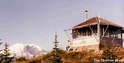
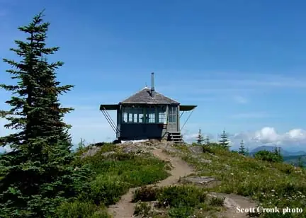
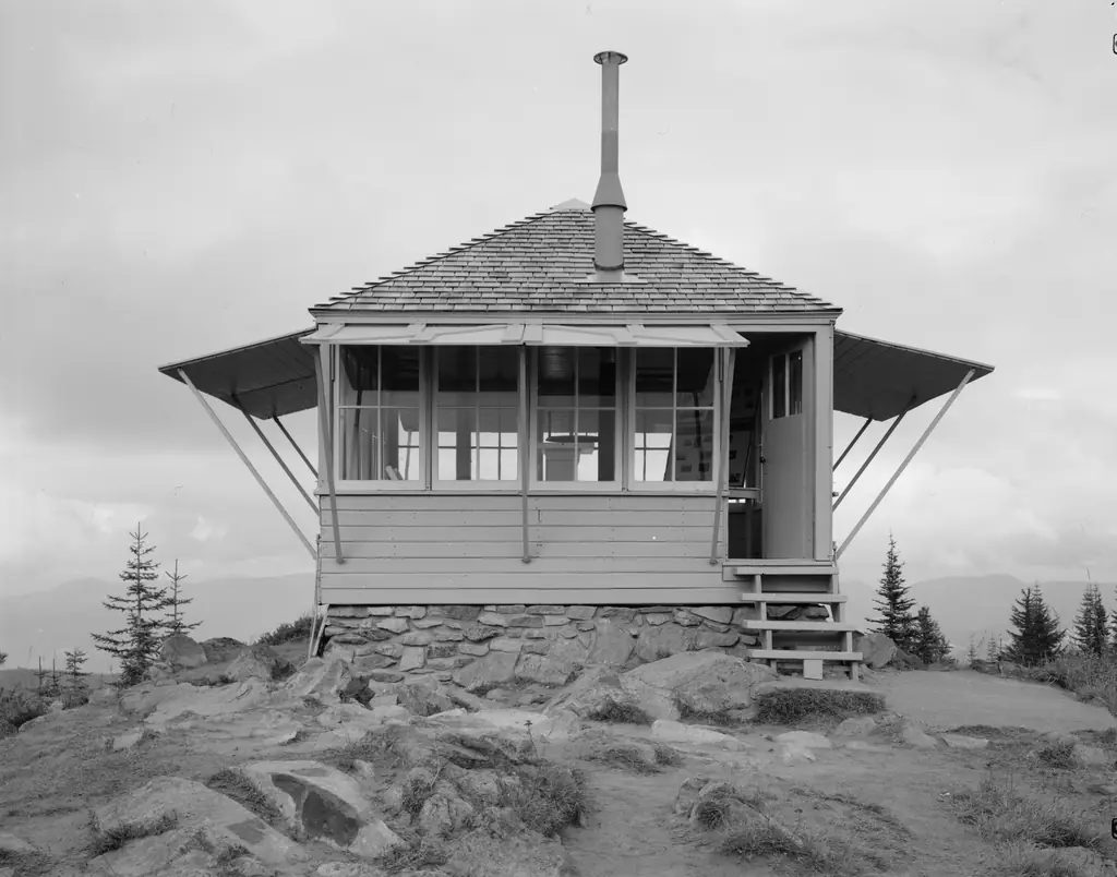
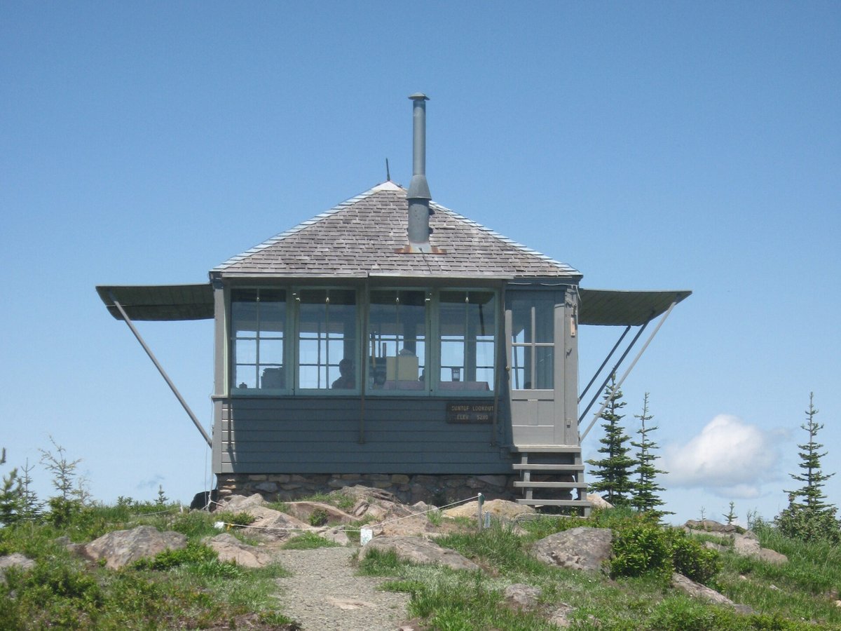
An L-4 ground house near Mt. Rainier built in the early 1930s (sources vary 1932-1934), used in WWII aircraft warning, and still volunteer-staffed in summer.
- Standing
- Open to the public
- Verified
Visit & stay
Not rentable. As far as we know, this lookout cannot be booked for overnight stays.
Access
Open to the public. Open to the public in summer; last mile of Forest Road 7315 generally gated unless staffed or work is underway, with a trail from the gate.
- Can you climb it?
- Yes
- Road to the top?
- No, you have to hike
- Trail
- Drive most of the way on FR 7315, then a short trail/final mile on foot; ramp added for disabled access.
- Staffing
- Staffed by volunteers
Facts
- Status
- Type
- Ground-level cabL-4 ground house, 14x14 ft, pyramidal roofThe design: L-4
- Built of
- WoodGoing by its design; no source says so in words.
- Also served as
- Aircraft Warning Service postDuring the Second World War it was staffed to spot and report aircraft.
- Built
- 1932 sources disagree
- Height
- Unknown
- Elevation
- 5,214 ft (1,589 m)
- Agency
- U.S. Forest Service
- Land
- Federal land
- Location
- Pierce County, Washington
- Coordinates
- 47.04091, −121.59639
- Registers
- This entry
- VerifiedResearched, then checked independently. Updated 8 Oct 2026.
- Firefinder id
us-wa-suntop
View from the cab
What you see from the cab: every ridge out to about 93 miles, the named peaks in sight, and other fire lookouts within view, worked out from terrain data in your browser.
Downloads about 3.9 MB of terrain data the first time.
Or see what it could see on the map: the ground in its line of sight.
History
Then and now
- 1932 BuiltNHLR states built in 1932.Source: nhlr.org
- 1933 BuiltWikipedia/NRHP area info gives 1932 or 1933 (NRHP record area says 'Built 1933').Source: en.wikipedia.org
- 1934 Builtfirelookout.com states the present L-4 cab was built in 1934.Source: firelookout.com
- 1942 EventUsed as a WWII U.S. Army Aircraft Warning System site (precise year approximate, WWII era).Sources: nhlr.org, en.wikipedia.org
- 1956 EventRoad to the lookout (Forest Road 7315) completed.Source: nhlr.org
- No record between 1956 and 1986
- 1986 RestoredMajor refurbishment, after which the cab was set on the rock foundation it still sits on.Source: snoqualmielookouts.org
- 1987 Listed on the National Register of Historic PlacesListed on the National Register of Historic Places, July 14, 1987.Source: en.wikipedia.org
- 1994 Added to the National Historic Lookout RegisterAdded to the National Historic Lookout Register, September 15, 1994.Source: en.wikipedia.org
- No record between 1994 and 2020
- 2020 ClosedVolunteer staffing suspended 2020-21 due to COVID.Source: nhlr.org
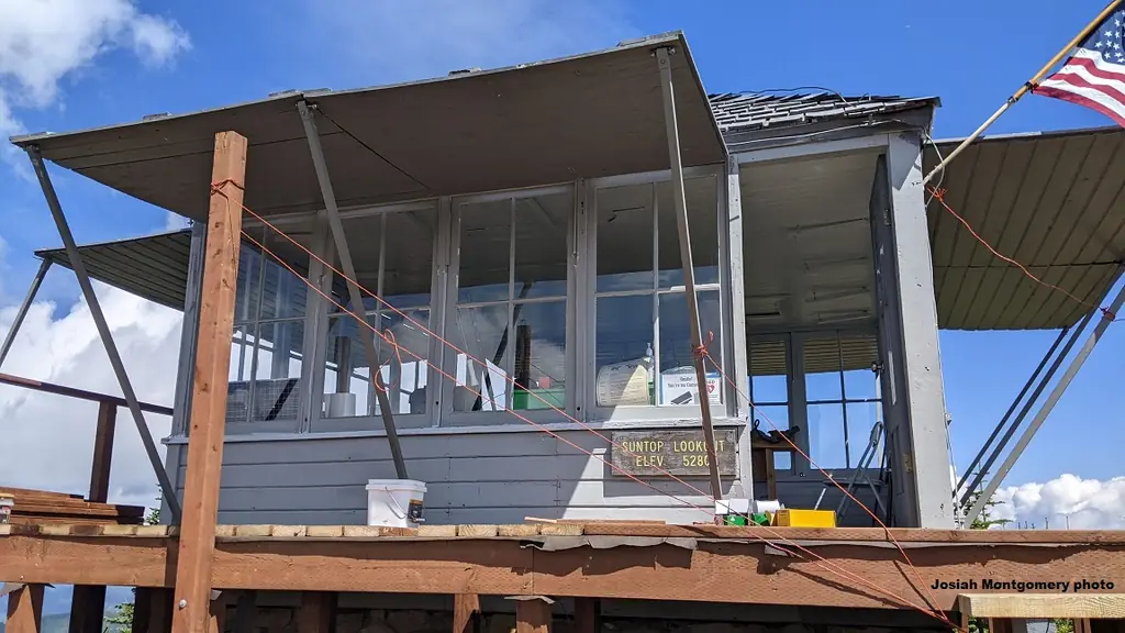
- 2025 AlteredModifications to make the lookout accessible to people with disabilities were completed, and it hosted its first visitors in wheelchairs.Sources: firelookout.org, firelookout.org
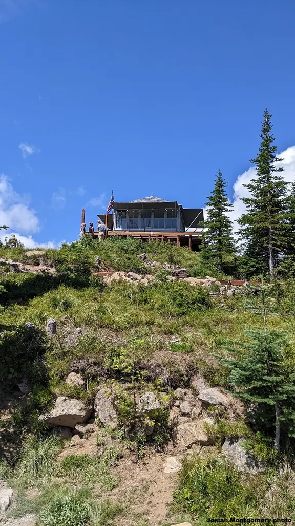
- 2025 RestoredInterior renovated to reflect 1960s fire equipment; trail, deck, and accessibility ramp added.Source: nhlr.org
- TodayStandingIt still stands, as far as our sources know.
Old maps of this spot
USGS topographic maps from the years a lookout stood may show it, often as a small symbol labelled “Lookout”. See the old topo maps around it on the Firefinder map, or find every scanned sheet of this spot on USGS TopoView (opens another site) (click the spot there to list them, with dates and downloads).
Story
Researched 4 Oct 2026, fact-checked.
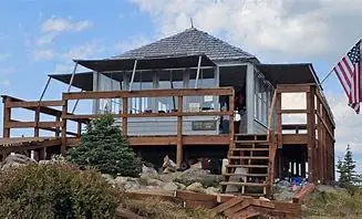
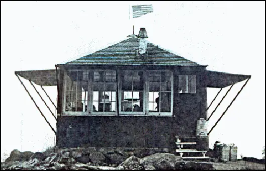
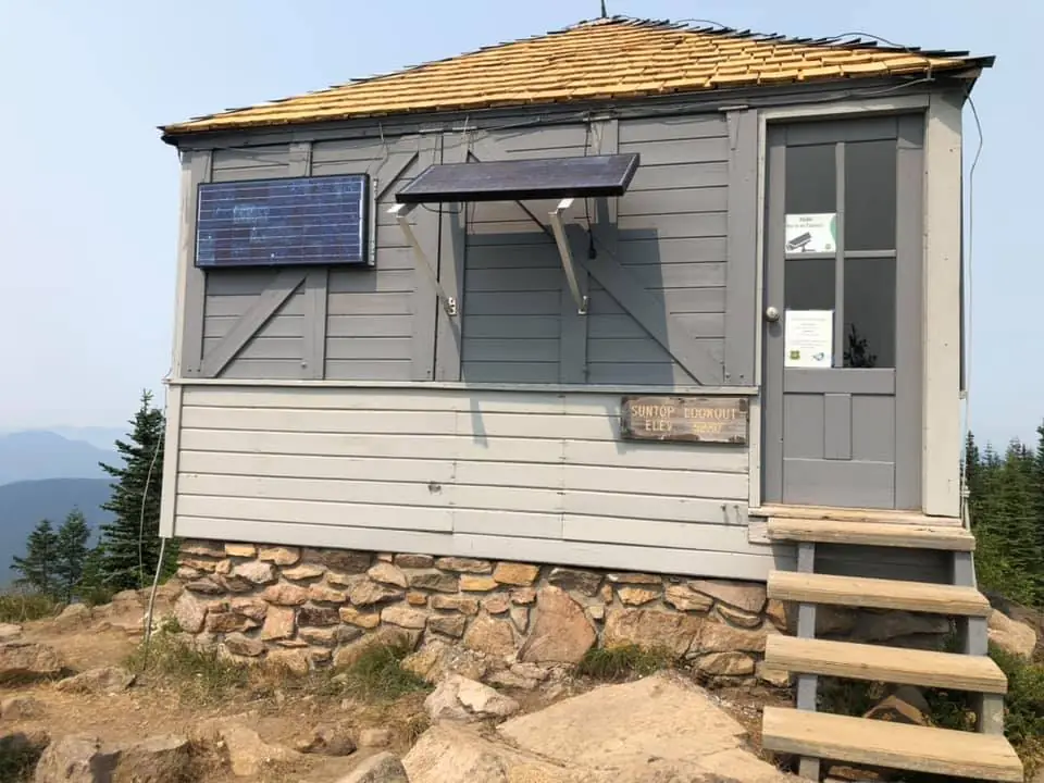
Sources don't fully agree on when Suntop Lookout went up. The National Historic Lookout Register gives 1932, Wikipedia says 1932 or 1933, the National Register of Historic Places nomination lists 1933, and firelookout.com says 1934.1,2,3 Whatever the exact year, it follows the Forest Service's standard "L-4 Lookout House" plan: a fourteen-foot-square, single-story frame cab at ground level, topped with a pyramid roof, with big windows on each face and sunshade shutters that swing out on hinges.2 It stands in the Mount Baker-Snoqualmie National Forest, about fifteen miles northeast of Mount Rainier, on a high alpine meadow with a view across to the Winthrop Glacier.1,2
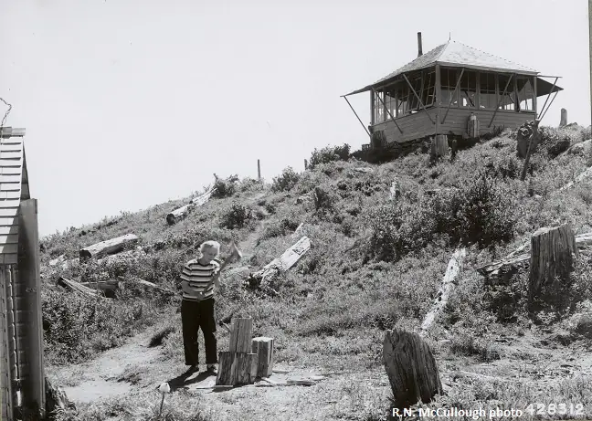
Of the L-4 ground houses once built across the old Snoqualmie National Forest, only two are still standing, and Suntop is one of them.1,2 During World War II it served as a lookout post in the U.S. Army's Aircraft Warning System, watching the sky rather than just the woods.1,2 The road up to it, Forest Road 7315, wasn't finished until 1956; before that, reaching the lookout took real effort.1
The lookout was listed on the National Register of Historic Places on July 14, 1987, and added to the National Historic Lookout Register on September 15, 1994.2 It has never been abandoned outright. It's staffed on and off by volunteers, including members of the Snoqualmie Fire Lookout Association, though staffing isn't constant; it was closed through the 2020-21 seasons because of COVID.1,3 As of 2025, the interior has been fitted out to reflect 1960s-era fire equipment, with period pieces like a crank phone and an old helmet, and the site has gained a new approach trail, a deck, and a ramp that lets it be reached by visitors with disabilities.1
Today the final mile is gated, and it typically stays that way except when someone is staffing the lookout or crews are up there working, so visitors cover that stretch on foot.1 The lookout is open to the public in summer months, but it is not a rental; visitors can look around and, when it's staffed, talk with the volunteers on duty.1,2
- Suntop Lookout, National Historic Lookout Register, http://nhlr.org/lookouts/us/wa/suntop-lookout/ (accessed 2026-10-04). ↩
- Suntop Lookout, Wikipedia, https://en.wikipedia.org/wiki/Suntop_Lookout (accessed 2026-10-04). ↩
- Suntop Mountain Lookout, firelookout.com, https://www.firelookout.com/wa/suntop.html (accessed 2026-10-04). ↩
Photos

Photos keep their own rights and are shown with credit. Is one of these yours? You can ask for a different credit or for removal.
Where sources disagree
We show disagreements between sources instead of quietly picking one. If you know which is right, please tell us.
Sources disagree on the year it was built.
- firelookout.com -- Rex Kamstra's Forest Fire Lookout Page: 1934
- recreation.gov: 1933
- Wikidata: 1933
- TrailChick: Washington State Fire Lookouts: 1932
- Snoqualmie Fire Lookouts Association: 1932
Sources give different build years. Often one counts the first lookout on the site and another the structure there now.
Sources
- National Historic Lookout Register (NHLR) (opens another site) Gave us: name, location, county, elevation, wartime use, register numbers, agency, dates, photos, links National Historic Lookout Register (nhlr.org) · All rights reserved (American Resources, Inc.); facts extracted only, no prose copied. · retrieved 4 Oct 2026
- Forest Fire Lookout Association (FFLA) - US lookout lists (opens another site) Gave us: type, status, register numbers, links Forest Fire Lookout Association (firelookout.org) · No licence stated; facts extracted only, no prose copied. · retrieved 8 Oct 2026
- Recreation Information Database (recreation.gov) (opens another site) Gave us: ownership, access Data source: ridb.recreation.gov · Public data from the US government · retrieved 12 Oct 2026
- firelookout.com -- Rex Kamstra's Forest Fire Lookout Page (opens another site) Gave us: what it is built of, design, staffing, dates, photos, links firelookout.com · No licence stated on the site; facts only (coordinates, elevation, built/destroyed years, design, agency). Photos mirrored with the site's stated credit. · retrieved 4 Oct 2026
- Snoqualmie Fire Lookouts Association (opens another site) Gave us: dates, links Snoqualmie Fire Lookouts Association (snoqualmielookouts.org) · No licence stated; facts only (dates, names, the kind of work done). Every note is our own wording and every event links to the association's page it comes from. Positions are copied from the NHLR records. · retrieved 8 Oct 2026
- Forest Fire Lookout Association chapter reports (opens another site) Gave us: dates, links Forest Fire Lookout Association, chapter and restoration-grant reports (firelookout.org) · No licence stated; facts only (dates, names, the kind of work done). Every note is our own wording and every event links to the FFLA report it comes from. Positions are copied from the NHLR, FFLOS and FFLA records. · retrieved 8 Oct 2026
- Wikidata -- US fire lookout towers (Q748998 and subclasses) (opens another site) Gave us: register numbers, photos, links Wikidata · CC0 1.0 (Wikidata). Images keep their own Commons licence/credit. · retrieved 4 Oct 2026
- OpenStreetMap -- fire lookout structures (opens another site) Gave us: links © OpenStreetMap contributors · ODbL 1.0. (c) OpenStreetMap contributors. · retrieved 4 Oct 2026
- FOREST LOOKOUTS -- western US (Ron Kemnow's weebly sites) (opens another site) Gave us: links Ron Kemnow's Forest Lookouts sites (westlookouts, californialookouts, idaholookouts, montanalookouts, oregonlookouts and washingtonlookouts .weebly.com) · No licence stated; facts only (county, land manager, status word, coordinates where the page's own map widget gives them, township-range-section, height and design hints, links). The site's own newspaper quotes, citations and narrative are not reproduced. · retrieved 8 Oct 2026
- TrailChick: Washington State Fire Lookouts (opens another site) Gave us: photos, links TrailChick (trailchick.com) · No licence stated; facts only (county, land manager, coordinates, elevation, lookout type, years built). The guide's text is not reproduced; its card photos are listed with credit to TrailChick, for the project's photo mirroring. · retrieved 8 Oct 2026
- FFLA chapters, affiliates and Friends groups: lookout pages (opens another site) FFLA chapters and Friends groups (each link names the group) · Links to the groups' own pages; facts only from the California-South chapter's tower table (register page, operator, condition). No text or photos reproduced. · retrieved 8 Oct 2026
- WillhiteWeb.com: Washington Fire Lookouts (opens another site) Gave us: links WillhiteWeb.com · No licence stated; names and page links only (the site's photos and text are not reproduced). · retrieved 8 Oct 2026
- Firefinder research Gave us: summary, design, status, agency, access, visiting details, dates, links, fact-check Firefinder research (sources cited in the story footnotes) · Our own research notes; each fact cites its source in the lookout's story
More about this lookout elsewhere
- NHLR register entry US 92 (nhlr.org) (opens another site)
- NHLR register entry (nhlr.org) (opens another site)
- FFLA Washington lookout list (firelookout.org) (opens another site)
- Snoqualmie Fire Lookouts Association: work on Suntop Lookout (opens another site)
- Forest Fire Lookout Association chapter reports: work on Suntop Lookout (opens another site)
- Wikipedia: Suntop Lookout (opens another site)
- Suntop Mtn. on firelookout.com (Rex Kamstra) (opens another site)
- Suntop Mountain on Forest Lookouts, western US (Ron Kemnow) (opens another site)
- Sun Top in the TrailChick Washington lookout guide (opens another site)
- Sun Top on WillhiteWeb.com Washington Fire Lookouts (opens another site)
- Wikidata item Q14713913 (opens another site)
- OpenStreetMap way 363988059 (opens another site)
Firefinder takes facts (places, dates, numbers) from these sources and writes its own words. See all sources and licences.