Fire lookout · Kittitas County, Washington
Thorp Mountain Lookout
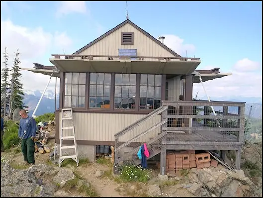
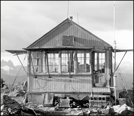
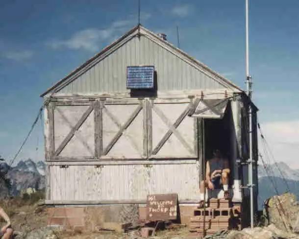
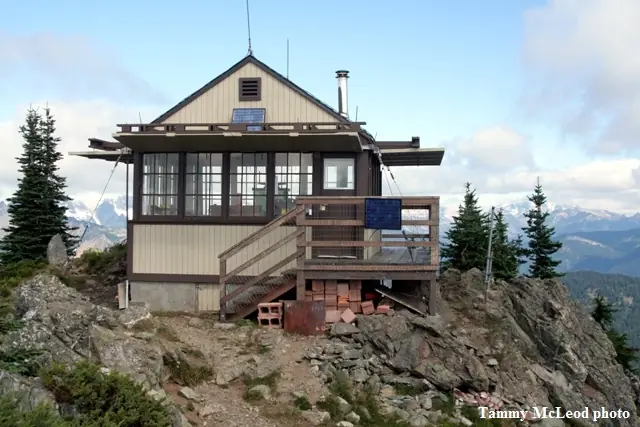
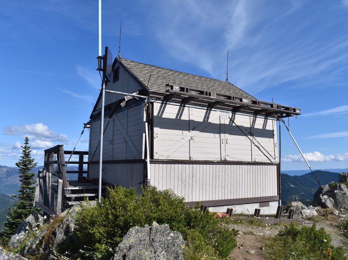
Kittitas County hike-in L-4 ground house built 1930 for the Forest Service; NHLR-listed 2001, renovated 2007-08, staffing disputed, 2026 volunteer repair project.
- Standing
- Open to the public
- Verified
Visit & stay
Not rentable. As far as we know, this lookout cannot be booked for overnight stays.
Access
Open to the public. Reached on foot. The WTA route from Thorp Creek is 7.4 miles round trip; a WTA note dated 8.24.26 says that trail was closed for the Three Queens Fire.
- Can you climb it?
- Unknown
- Road to the top?
- No, you have to hike
- Trail
- TrailChick lists it as a hike in and gives driving directions to the trailheads. The Thorp Creek route is 7.4 miles round trip with 2,484 feet of gain, per WTA.
- Staffing
- Unknown
Facts
- Status
- Type
- Ground-level cab14 by 14 foot gable-roofed L-4 ground house built in 1930The design: L-4
- Built of
- Wood
- Built
- 1930
- Height
- Unknown
- Elevation
- 5,582 ft (1,701 m)
- Agency
- U.S. Forest Service (Okanogan-Wenatchee National Forest)
- Land
- Federal land
- Location
- Kittitas County, Washington
- Coordinates
- 47.37080, −121.20710
- Registers
- This entry
- VerifiedResearched, then checked independently. Updated 8 Oct 2026.
- Firefinder id
us-wa-thorp-mountain
View from the cab
What you see from the cab: every ridge out to about 93 miles, the named peaks in sight, and other fire lookouts within view, worked out from terrain data in your browser.
Downloads about 4.4 MB of terrain data the first time.
Or see what it could see on the map: the ground in its line of sight.
History
Then and now
- 1930 BuiltBuilt by the Forest Service as a 14-by-14-foot L-4 gable-roofed ground house.Sources: nhlr.org, firelookout.com, historicorps.org
- No record between 1930 and 2001
- 2001 Added to the National Historic Lookout RegisterRegistered on the National Historic Lookout Register on September 1, 2001.Sources: nhlr.org, historicorps.org
- 2007 RestoredThe register says it was completely refurbished in the summer of 2007.Source: nhlr.org
- 2008 Alteredfirelookout.com dates extensive maintenance to about 2008; TrailChick says the 2008 renovations did not necessarily follow the original design.Sources: firelookout.com, trailchick.com
- No record between 2008 and 2024
- 2024 EventTrailChick, updated March 2024, says it is no longer volunteer staffed because of carbon monoxide from the stove.Source: trailchick.com
- 2026 ClosedWTA note dated 8.24.26 says the Thorp Creek trail is closed because of the Three Queens Fire.Source: wta.org
- 2026 EventHistoriCorps volunteer repair sessions were set for two sessions, September 7-13 and September 16-22, 2026.Source: historicorps.org
- 2026 RestoredHistoriCorps scheduled two volunteer sessions in September, hiking in, to rebuild the shutters in kind and repair the catwalk, door and paint.Source: historicorps.org
- TodayStandingIt still stands, as far as our sources know.
Old maps of this spot
USGS topographic maps from the years a lookout stood may show it, often as a small symbol labelled “Lookout”. See the old topo maps around it on the Firefinder map, or find every scanned sheet of this spot on USGS TopoView (opens another site) (click the spot there to list them, with dates and downloads).
Story
Researched 8 Oct 2026, fact-checked.
Thorp Mountain Lookout sits on the summit of Thorp Mountain in Kittitas County, Washington.1,2 The register places it in the Wenatchee National Forest.1 HistoriCorps says the Okanogan National Forest was combined with the Wenatchee National Forest in 2000, and TrailChick uses the name Okanogan-Wenatchee National Forest.2,3
The U.S. Forest Service built the lookout in 1930 as a 14-by-14-foot gable-roofed L-4 cabin.1,2 HistoriCorps describes it as one of the few surviving gable-roofed L-4 cab lookouts in the Northwest.2 The register lists it with a registration date of September 1, 2001, and HistoriCorps says it was listed on the register that year.1,2
According to the register, the lookout got a complete refurbishment in summer 2007.1 firelookout.com dates its extensive maintenance to about 2008, and TrailChick says the 2008 renovations did not necessarily follow the original design.4,3 The sources give different years for the work.1,4,3
Staffing is where the sources disagree.1,4,3 The register says the lookout is currently staffed seven days a week.1 TrailChick, updated in March 2024, says it is no longer volunteer staffed because of carbon monoxide from the stove, though the Forest Service still uses it in periods of high fire danger.3 firelookout.com describes it as available for emergencies.4
HistoriCorps planned a volunteer repair project on the lookout, which it describes as deteriorated.2 The two sessions were set for September 7–13 and September 16–22, 2026, with the Mountains to Sound Greenway Trust as partner.2
TrailChick lists Thorp as a hike in, though it gives driving directions to the trailheads.3 The Washington Trails Association route from Thorp Creek covers 7.4 miles round trip with 2,484 feet of gain.5 A WTA note dated 8.24.26 says that trail was closed because of the Three Queens Fire.5
The sources also give three elevations.1,4,5,3 The register lists 5,582 feet, firelookout.com and TrailChick list 5,854 feet, and WTA gives 5,884 feet as the route's highest point.1,4,3,5
- Thorp Mountain Lookout, National Historic Lookout Register, http://nhlr.org/lookouts/us/wa/thorp-mountain-lookout/ (accessed 2026-10-08). ↩
- HardCorps: Thorp Mountain Lookout, WA 2026, HistoriCorps, https://historicorps.org/hardcorps-thorp-mountain-lookout-wa-2026/ (accessed 2026-10-08). ↩
- Thorp Mountain, TrailChick, https://www.trailchick.com/wa-state-fire-lookouts/thorp-mountain-lookout/ (accessed 2026-10-08). ↩
- Thorp Mtn. Fire Lookout Cabin, firelookout.com, https://www.firelookout.com/wa/thorp.html (accessed 2026-10-08). ↩
- Thorp Mountain Lookout via Thorp Creek, Washington Trails Association, https://www.wta.org/go-hiking/hikes/thorp-mountain-lookout-via-thorp-creek (accessed 2026-10-08). ↩
Photos
Photos keep their own rights and are shown with credit. Is one of these yours? You can ask for a different credit or for removal.
Sources
- National Historic Lookout Register (NHLR) (opens another site) Gave us: name, location, county, elevation, register numbers, agency, ownership, dates, photos, links National Historic Lookout Register (nhlr.org) · All rights reserved (American Resources, Inc.); facts extracted only, no prose copied. · retrieved 4 Oct 2026
- Forest Fire Lookout Association (FFLA) - US lookout lists (opens another site) Gave us: type, status, register numbers, links Forest Fire Lookout Association (firelookout.org) · No licence stated; facts extracted only, no prose copied. · retrieved 8 Oct 2026
- firelookout.com -- Rex Kamstra's Forest Fire Lookout Page (opens another site) Gave us: design, dates, photos, links firelookout.com · No licence stated on the site; facts only (coordinates, elevation, built/destroyed years, design, agency). Photos mirrored with the site's stated credit. · retrieved 4 Oct 2026
- HistoriCorps (opens another site) Gave us: dates, links HistoriCorps (historicorps.org) · No licence stated; facts only (dates, the kind of work planned). Every note is our own wording and every event links to the HistoriCorps page it comes from. Positions are copied from the NHLR records. · retrieved 8 Oct 2026
- Forest Fire Lookout Association chapter reports (opens another site) Gave us: dates, links Forest Fire Lookout Association, chapter and restoration-grant reports (firelookout.org) · No licence stated; facts only (dates, names, the kind of work done). Every note is our own wording and every event links to the FFLA report it comes from. Positions are copied from the NHLR, FFLOS and FFLA records. · retrieved 8 Oct 2026
- OpenStreetMap -- fire lookout structures (opens another site) Gave us: what it is built of, register numbers, access, links © OpenStreetMap contributors · ODbL 1.0. (c) OpenStreetMap contributors. · retrieved 4 Oct 2026
- FOREST LOOKOUTS -- western US (Ron Kemnow's weebly sites) (opens another site) Gave us: links Ron Kemnow's Forest Lookouts sites (westlookouts, californialookouts, idaholookouts, montanalookouts, oregonlookouts and washingtonlookouts .weebly.com) · No licence stated; facts only (county, land manager, status word, coordinates where the page's own map widget gives them, township-range-section, height and design hints, links). The site's own newspaper quotes, citations and narrative are not reproduced. · retrieved 8 Oct 2026
- TrailChick: Washington State Fire Lookouts (opens another site) Gave us: photos, links TrailChick (trailchick.com) · No licence stated; facts only (county, land manager, coordinates, elevation, lookout type, years built). The guide's text is not reproduced; its card photos are listed with credit to TrailChick, for the project's photo mirroring. · retrieved 8 Oct 2026
- WillhiteWeb.com: Washington Fire Lookouts (opens another site) Gave us: links WillhiteWeb.com · No licence stated; names and page links only (the site's photos and text are not reproduced). · retrieved 8 Oct 2026
- Firefinder research Gave us: summary, design, status, agency, access, visiting details, dates, links, fact-check Firefinder research (sources cited in the story footnotes) · Our own research notes; each fact cites its source in the lookout's story
More about this lookout elsewhere
- NHLR register entry US 389 (nhlr.org) (opens another site)
- Thorp Mountain Lookout via Thorp Creek (Washington Trails Association) (opens another site)
- FFLA Washington lookout list (firelookout.org) (opens another site)
- HistoriCorps: work on Thorp Mountain Lookout (opens another site)
- Forest Fire Lookout Association chapter reports: work on Thorp Mountain Lookout (opens another site)
- Thorp Mtn. on firelookout.com (Rex Kamstra) (opens another site)
- Thorp Mountain on Forest Lookouts, western US (Ron Kemnow) (opens another site)
- Thorp Mountain in the TrailChick Washington lookout guide (opens another site)
- Thorp Mountain on WillhiteWeb.com Washington Fire Lookouts (opens another site)
- Wikidata item Q86868347 (opens another site)
- OpenStreetMap way 1558990792 (opens another site)
Firefinder takes facts (places, dates, numbers) from these sources and writes its own words. See all sources and licences.